The Newport Tower

The Newport Tower
Medieval stone tower ... in Rhode Island. Does it look like any other Colonial structure you've seen? Recent carbon dating of the mortar indicates 1400s construction date (see post below).

The Westford Knight Sword

The Westford Knight Sword
Medieval Battle Sword ... in Westford, Massachusetts. Can anyone deny the pommel, hilt and blade punch-marked into the bedrock?

The Spirit Pond Rune Stone

The Spirit Pond Rune Stone
Medieval Inscription ... in Maine, near Popham Beach. Long passed off as a hoax, but how many people know the Runic language? And how is it that some of the Runic characters match rare runes on inscriptions found in Minnesota and Rhode Island? Carbon-dating of floorboards at nearby long house date to 1405.

The Narragansett Rune Stone

The Narragansett Rune Stone
Medieval Inscription ... in Rhode Island's Narragansett Bay. This Runic inscription is only visible for twenty minutes a day at low tide--is this also the work of a modern-day, Runic-speaking hoaxster?

The Westford Boat Stone

The Westford Boat Stone
Medieval Ship Carving ... in Westford, MA. Found near the Westford Knight site. Weathering patterns of carving are consistent with that of 600-year-old artifact. And why would a Colonial trail-marker depict a knorr, a 14th-century ship?

The Kensington Rune Stone

The Kensington Rune Stone
Medieval Inscription... in Minnesota. Forensic geology confirms the carvings predate European settlement of Minnesota--so did Runic-speaking Native Americans carve it?

The Hooked X Rune

The Hooked X Rune
Medieval Runic Character ... on inscriptions found in Maine, Minnesota and Rhode Island. But this rare rune was only recently found in Europe. This conclusively disproves any hoax theory while also linking these three artifacts together.

Tuesday, February 21, 2023

In justification for issuing his Papal Bull banning Catholics from becoming Freemasons in the mid-1800s, Pope Pius IX accused the Knights Templar of secretly being Johannites—that is, worshipers of John the Baptist rather than of Jesus. Pius, believing that Freemasonry evolved from the Templar order, ascribed the same belief to Freemasonry. I first researched the Templar/Masonic connection to Johannism while writing Thief on the Cross, released in 2013. I learned that the Dead Sea Scrolls spoke of a prophecy during the time of Jesus which declared that there would be two messiahs rather than one—Jesus and John the Baptist, with John the Baptist (not Jesus) being the one chosen eventually to sit at God’s right hand. Apparently the Templars, having learned of this prophecy, began to worship John the Baptist. You may recall that the Church turned on the Templars in 1307, accusing them of heresy. In particular, the Church accused the Templars of worshiping a head known as Baphomet. Was this an accurate charge? In particular, were the Templars—as Johannites—worshiping the head of John the Baptist, beheaded in the first century by King Herod? (Baptist … Baptism … Baphomet?) And is that the reason the Freemasons—even today known as “John’s Brothers”—venerate John the Baptist and reserve his June 24 birthday for special occasions and ceremonies? A decade later, I am revisiting that research. Specifically, the Mandaean people of southern Iraq and Iran recently have been displaced by ugly wars in their region. The Mandaeans are the only known sect of Johannites in the modern world. Due to their displacement, Mandaean sacred texts have come to light. These texts—including eye-opening passages describing Jesus as “the evil usurper”—offer fresh insights into Johannism. One tantalizing possibility is that Mary Magdalene may have been a Mandaean priestess. In fact, she and John the Baptist may even have been husband and wife. As part of this research, I am taking a fresh look at Leonard da Vinci’s paintings. As Dan Brown famously wrote, da Vinci was purportedly part of a secret society intimately tied to the Templars (some even say he was a Templar Grand Master). I have been focusing in particular on the five depictions of John the Baptist I have found in da Vinci’s paintings. They all feature the so-called John gesture, in which John the Baptist is pointing to the heavens with his forefinger, as if to say, “I am ascending.” Here is one example:
Even da Vinci’s students seem to have carried on this tradition. Here is a sculpture by Giovanni Fransesco Rustici, who was living with da Vinci during the time of this work:
I have been thinking about this gesture, wondering what else could it mean?

Tuesday, December 7, 2021

NEWPORT TOWER WINTER SOLSTICE. A group of us will be heading down to Newport, RI on Sunday, Dec. 19 to view the Tower solstice illumination. There is a “starburst” illumination at around 8:00 AM and then the main alignment (image below) begins around 8:45 and ends at 9:15. Long-range weather looks good, but things could change as the day approaches. Message me if interested.

Friday, July 23, 2021

I don’t often weigh in on the Oak Island mystery, though I do regularly watch the Curse of Oak Island show. There are plenty of capable and qualified researchers working on this mystery, and I prefer to focus on less well-known historical enigmas. However, as a Templar historian, I do sometimes uncover things relevant to the Oak Island mystery. I did so recently, something which, unless it somehow turns out to be invalid, ties the Templars to Oak Island with a high level of certainty: coconut fibers.

Coconut fibers have long been associated with the flood tunnels at Oak Island. As the theory goes, the fibers were used to prevent blockage of the box drains in the beach area of Smith’s Cove; these drains fed the flood tunnels, part of the booby-trap system used to protect the treasure buried underground in what has come famously to be known as the Money Pit. Coconuts, of course, are not native to Nova Scotia. And it is absurd to think they had floated up the coast of the Eastern Seaboard, as I have heard one archeologist suggest. Yet there they were.

I stumbled upon a research report compiled by Les MacPhie reporting on samples of the Oak Island coconut fiber having been subjected to carbon-dating by commercial laboratories. (A copy of the online report can be found here: https://www.oakislandtours.ca/.../b09_oak_island_carbon... . The second page of the report is reproduced below.) According to the report, a 1990 test by Beta Analytic yielded a date of 1180 AD, +- 60. A second test in 1996 by Woods Hole Oceanographic Institute yielded the remarkably similar date of 1185 AD, +- 35.

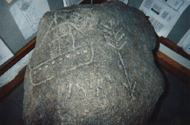
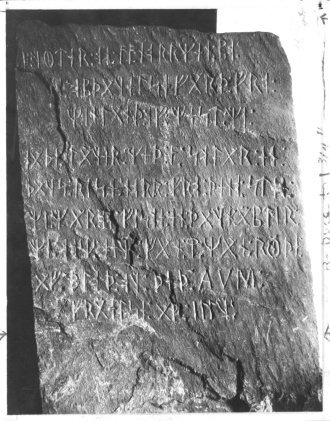
These dates jumped out me, being almost an exact match to the 1179 date of a purported Templar voyage to Oak Island (continuing on to the Catskill Mountains of New York) as described in the so-called Cremona Document, first extensively written about in 2017 by historian Zena Halpern. See The Templar Mission to Oak Island and Beyond, by Zena Halpern (CreateSpace 2017). See also The Scrolls of Onteora—The Cremona Document, by Donald A. Ruh (Lulu 2018). According to Halpern, the Templars deposited some or all of their treasure on Oak Island at a place labeled on a map (see below) of the island as “Le Voute en Bas de Terre,” or “The Vault Beneath the Earth” (left arrow). The map itself was labeled “Les Isle des Chene,” or “The Island of Oaks” (right arrow). (Note that this map displays a date of “1347” [not shown], perhaps indicating that it was drawn during a return visit by the Templars, subsequent to their original 1179 arrival.) This map has been regularly featured on the Curse of Oak Island show.


All of the above is available in the public record. What I was not aware of was the fact that coconuts are not native to the Americas. As of the twelfth century, coconuts were grown only in India, eastern Africa, Southeast Asia, and perhaps also Panama, but on the Pacific coast only. https://en.wikipedia.org/wiki/Coconut#Origin The Templars, it should be noted, were purported to have traveled extensively to Ethiopia (on the east coast of Africa) in the late twelfth century. See Graham Hancock, The Sign and the Seal (Touchstone 1992), at pages 103-117.

This, to me, was eye-opening. Someone brought the coconut fiber to Oak Island from one of these remote locations. Who, other than the Templars, had the wherewithal to do so in the twelfth century?

For anyone with an open mind, this evidence is difficult to shrug away.

Wednesday, July 7, 2021


My “Romerica” book focuses on dozens of Roman-era artifacts, coins and stone structures scattered around New England and the Ohio River Valley. In the book I speculate that these objects may be related to the Roman Ninth Legion, which mysteriously disappeared from the historical record after helping put down the Bar Kokhba uprising in Jerusalem in 135 AD. Since the book came out last November, I have learned of two new sites which add additional support to the possibility that Roman-era explorers came to America around the second century.

First, a site in the Shenandoah Valley in western Virginia appears to be an ancient iron smelting operation. I recently visited this site, known as the Arkfeld Farm. The owner has done meticulous work documenting his finds and has brought in outside experts to help with testing and dating the site. Here is a picture of what he believes to be part of the remains of the smelting operation:


        From the site, he had three different samples tested at the University of Washington using Optically Stimulated Luminescence testing. He tested a brick, a mortar/cement sample, and a piece of slag (a byproduct of iron smelting). The results are as follows:

            Brick Date: 10 AD +-160

            Slag Date: 30 BC +-700

            Mortar Date: 150 AD +-100

    Furthermore, the owner has documented similarities between this site and an iron smelting site dating to the Roman era located near Hadrian’s Wall at the England-Scotland border. In what may be a crucial piece to this puzzle, Hadrian’s Wall was built and patrolled by the Roman Ninth Legion. (Note that there is no known evidence of Native American iron smelting operations in North America.)

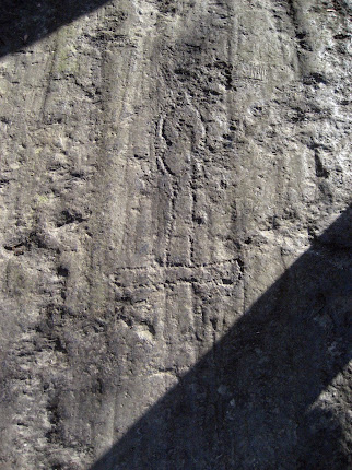
    Second, an inscription along the shoreline in York Harbor, Maine appears to date back to the Roman era. The inscription, evidencing considerable aging, consists of two lines of Roman letters. According to one source, the lettering reflects a version of the Roman alphabet not used after the 4th century AD. (Images below are 1) photograph of inscription and 2) “chalked-in” version, both from 1968.)  


    The script appears to be an excerpt from Virgil’s Aeneid, written c. 19 BC, and translates to: “There is far off at sea and facing a storm-beaten shoreline, a reef often wholly submerged, and pounded by the towering breakers.” Some commentators suggest the reef in question refers to nearby Boon Island, where mooring holes 2-3 inches in diameter and 1 foot deep have been found.

    Both these sites appear to add corroboration to the assertions made in “Romerica” that Roman-era explorers made their way across the Atlantic.

Monday, September 17, 2018

Columbus and the Templars


Was Columbus using old Templar maps when he crossed the Atlantic? At first blush, the navigator and the fighting monks seem like odd bedfellows. But once I began ferreting around in this dusty corner of history, I found some fascinating connections. Enough, in fact, to trigger the plot of my latest novel, The Swagger Sword.

To begin with, most history buffs know there are some obvious connections between Columbus and the Knights Templar. Most prominently, the sails on Columbus’ ships featured the unique splayed Templar cross known as the cross pattée (pictured here is the Santa Maria):


Additionally, in his later years Columbus featured a so-called “Hooked X” in his signature, a mark believed by researchers such as Scott Wolter to be a secret code used by remnants of the outlawed Templars (see two large X letters with barbs on upper right staves pictured below):


Other connections between Columbus and the Templars are less well-known. For example, Columbus grew up in Genoa, bordering the principality of Seborga, the location of the Templars’ original headquarters and the repository of many of the documents and maps brought by the Templars to Europe from the Middle East. Could Columbus have been privy to these maps? Later in life, Columbus married into a prominent Templar family. His father-in-law, Bartolomeu Perestrello (a nobleman and accomplished navigator in his own right), was a member of the Knights of Christ (the Portuguese successor order to the Templars). Perestrello was known to possess a rare and wide-ranging collection of maritime logs, maps and charts; it has been written that Columbus was given a key to Perestrello’s library as part of the marriage dowry. After marrying, Columbus moved to the remote Madeira Islands, where a fellow resident, John Drummond, had also married into the Perestrello family. Drummond was a grandson of Scottish explorer Prince Henry Sinclair, believed to have sailed to North America in 1398. It is, accordingly, likely that Columbus had access to extensive Templar maps and charts through his familial connections to both Perestrello and Drummond.
Another little-known incident in Columbus’ life sheds further light on the navigator’s possible ties to the Templars. In 1477, Columbus sailed to Galway, on the west coast of Ireland, from where the legendary Brendan the Navigator supposedly set sale in the 6th century on his journey to North America. While there, Columbus prayed at St. Nicholas’ Church, a structure built over an original Templar chapel dating back to around the year 1300. St. Nicholas’ Church has been compared by some historians to Scotland’s famous Roslyn Chapel, complete with Templar tomb, Apprentice Pillar, and hidden Templar crosses. (Recall that Roslyn Chapel was built by another grandson—not Drummond—of the aforementioned Prince Henry Sinclair.) According to his diary, Columbus also famously observed “Chinese” bodies floating into Galway harbor on driftwood, which may have been what first prompted him to turn his eyes westward. A granite monument along the Galway waterfront, topped by a dove (Columbus meaning ‘dove’ in Latin), commemorates this sighting, the marker reading: On these shores around 1477 the Genoese sailor Christoforo Colombo found sure signs of land beyond the Atlantic.


In fact, as the monument text hints, Columbus may have turned more than just his eyes westward. A growing body of evidence indicates he actually crossed the north Atlantic in 1477. Columbus wrote in a letter to his son: “In the year 1477, in the month of February, I navigated 100 leagues beyond Thule [to an] island which is as large as England. When I was there the sea was not frozen over, and the tide was so great as to rise and fall 26 braccias.” We will turn later to the mystery as to why any sailor would venture into the north Atlantic in February. First, let’s examine Columbus’ statement. Historically, ‘Thule’ is the name given to the westernmost edge of the known world. In 1477, that would have been the western settlements of Greenland (though abandoned by then, they were still known). A league is about three miles, so 100 leagues is approximately 300 miles. If we think of the word “beyond” as meaning “further than” rather than merely “from,” we then need to look for an island the size of England with massive tides (26 braccias equaling approximately 50 feet) located along a longitudinal line 300 miles west of the west coast of Greenland and far enough south so that the harbors were not frozen over. Nova Scotia, with its famous Bay of Fundy tides, matches the description almost perfectly. But, again, why would Columbus brave the north Atlantic in mid-winter? The answer comes from researcher Anne Molander, who in her book, The Horizons of Christopher Columbus, places Columbus in Nova Scotia on February 13, 1477. His motivation? To view and take measurements during a solar eclipse. Ms. Molander theorizes that the navigator, who was known to track celestial events such as eclipses, used the rare opportunity to view the eclipse elevation angle in order calculate the exact longitude of the eastern coastline of North America. Recall that, during this time period, trained navigators were adept at calculating latitude, but reliable methods for measuring longitude had not yet been invented. Columbus, apparently, was using the rare 1477 eclipse to gather date for future western exploration. Curiously, Ms. Molander places Columbus specifically in Nova Scotia’s Clark’s Bay, less than a day’s sail from the famous Oak Island, legendary repository of the Knights Templar missing treasure.

The Columbus-Templar connections detailed above were intriguing, but it wasn’t until I studied the names of the three ships which Columbus sailed to America that I became convinced the link was a reality. Before examining these ship names, let’s delve a bit deeper into some of the history referred to earlier in this analysis. I made a reference to Prince Henry Sinclair and his journey to North American in 1398. The Da Vinci Code made the Sinclair/St. Clair family famous by identifying it as the family most likely to be carrying the Jesus bloodline. As mentioned earlier, this is the same family which in the mid-1400s built Roslyn Chapel, an edifice some historians believe holds the key—through its elaborate and esoteric carvings and decorations—to locating the Holy Grail. Other historians believe the chapel houses (or housed) the hidden Knights Templar treasure. Whatever the case, the Sinclair/St. Clair family has a long and intimate historical connection to the Knights Templar. In fact, a growing number of researchers believe that the purpose of Prince Henry Sinclair’s 1398 expedition to North America was to hide the Templar treasure (whether it be a monetary treasure or something more esoteric such as religious artifacts or secret documents revealing the true teachings of the early Church). Researcher Scott Wolter, in studying the Hooked X mark found on many ancient artifacts in North American as well as on Columbus’ signature, makes a compelling argument that the Hooked X is in fact a secret symbol used by those who believed that Jesus and Mary Magdalene married and produced children. (See The Hooked X, by Scott F. Wolter.) These believers adhered to a version of Christianity which recognized the importance of the female in both society and in religion, putting them at odds with the patriarchal Church. In this belief, they had returned to the ancient pre-Old Testament ways, where the female form was worshiped and deified as the primary giver of life.

It is through the prism of this Jesus and Mary Magdalene marriage, and the Sinclair/St. Clair family connection to both the Jesus bloodline and Columbus, that we now, finally, turn to the names of Columbus’ three ships. Importantly, he renamed all three ships before his 1492 expedition. The largest vessel’s name, the Santa Maria, is the easiest to analyze: Saint Mary, the Virgin Mary, the mother of Jesus. The Pinta is more of a mystery. In Spanish, the word means ‘the painted one.’ During the time of Columbus, this was a name attributed to prostitutes, who “painted” their faces with makeup. Also during this period, the Church had marginalized Mary Magdalene by referring to her as ‘the prostitute,’ even though there is nothing in the New Testament identifying her as such. So the Pinta could very well be a reference to Mary Magdalene. Last is the Nina, Spanish for ‘the girl.’ Could this be the daughter of Mary Magdalene, the carrier of the Jesus bloodline? If so, it would complete the set of women in Jesus’ life—his mother, his wife, his daughter—and be a nod to those who opposed the patriarchy of the medieval Church. It was only when I researched further that I realized I was on the right track: The name of the Pinta before Columbus changed it was the Santa Clara, Portuguese for ‘Saint Clair.’

So, to put a bow on it, Columbus named his three ships after the Virgin Mary, Mary Magdalene, and the carrier of their bloodline, the St. Clair girl. These namings occurred during the height of the Inquisition, when one needed to be extremely careful about doing anything which could be interpreted as heretical. But even given the danger, I find it hard to chalk these names up to coincidence, especially in light of all the other Columbus connections to the Templars. Columbus was intent on paying homage to the Templars and their beliefs, and found a subtle way of renaming his ships to do so.

Given all this, I have to wonder: Was Columbus using Templar maps when he made his Atlantic crossing? Is this why he stayed south, because the maps showed no passage to the north? If so, and especially in light of his 1477 journey to an area so close to Oak Island, what services had Columbus provided the Templars in exchange for these priceless charts?

It is this research, and these questions, which triggered my novel, The Swagger Sword. If you appreciate a good historical mystery as much as I, I think you’ll enjoy the story.


Saturday, November 25, 2017

Newport Tower Research Updates


Developments in Newport Tower Research

There have been two recent developments I wanted to share. The first adds credence to the theory that the Newport Tower was NOT built as a Colonial windmill, and the second points to the builders as members of the 14th century Prince Henry Sinclair party.


Cartography


Renowned anthropologist and researcher Dr. Gunnar Thompson recently passed away, but before he did he posted to his website ( http://marcopoloinseattle.com ) a number of maps of the Narragansett Bay area which he had been researching. The first, a map dated 1569 by Gerhard Mercator, is shown here [cropped for clarity]:
 
The map clearly displays a European settlement at the northeastern end of Narragansett Bay, labeling the settlement “Norombega” and describing the settlement (not shown) as the capital city of the New World. Apparently, as of 1569, there was known to be a well-established European presence in the Newport area. (Newport is located on the eastern side of the bay, south of where the settlement is drawn.) Recall that the failed Roanoke colony was not established until 1585. And this 1569 also predates the Elizabethan-era expedition to Newport orchestrated by John Dee as proposed by researcher Jim Egan.

The conclusion that the Newport area had been settled in pre-Colonial times is further buttressed by a 1635 map drawn by William Wood, shown here:

 
Recall that Plymouth Colony was settled in 1620 by the Pilgrims. And note the label “New Plymouth” located east of Plymouth Harbor in Cape Cod Bay (you may need to zoom in). What is curious is that at the northeastern part of Narragansett Bay, where Mercator marked Norombega, there is a settlement labeled “Old Plymouth” on this map (again, zoom in). The first Colonial settlers did not arrive in Rhode Island until 1936, after this map was drawn, so this “Old Plymouth” cannot mark a Colonial settlement. Again, as we saw with the Mercator map, there seems to be a memory of some kind of ancient European settlement in the Narragansett Bay area.
 
Of course, these maps don’t prove that the Newport Tower is pre-Colonial. But they do show strong evidence of a pre-Colonial settlement in the Newport area. It is entirely possible that the Tower is part of that settlement.
 
Native American Oral History
 
So if the Tower predates the Colonists, who built it? Readers of my books know that I believe the leading candidate to have done so was Prince Henry Sinclair and his party in or around 1399. (Sinclair ruled Scottish lands near Edinburgh as wells as Norwegian lands in the Orkney Islands; his family also had a longstanding relationship with the outlawed Knights Templar.) In previous posts, and in my books and lectures, I have outlined the various reasons for this. But, until recently, I had never asked the one group of people who were actually here when I believe the Tower was built: The Native Americans.
 
In June of 2015, Pocasset Wampanoag Tribal Chief Daryl “Black Eagle” Jamieson joined a group of us at the Tower. When asked, Black Eagle replied that, according to what had been passed down to him by tribal elders, the Tower had been build by Henry Sinclair and the Knights Templar. He pointed out that whoever built the Tower must have had an alliance with the Native Americans in the area (ruling out the Colonists and also the Elizabethan-era British), else the Native Americans simply would have driven them off long before the Tower could have been completed. (A more complete excerpt of Black Eagle’s response is set forth below.)

My sincere thanks to Black Eagle for his candor and his willingness to help us solve the mystery of who built this amazing Tower.
**************************************
 
Black Eagle comments June, 2015:
“The Narragansett history is that the people that built this Tower are people that came here with red hair... They were red-haired people building here and they were allowed to build here—allowed... To me, the only person that could have came here and gotten away with that is somebody that was brought here by another native tribe... They would have had to have had some kind of alliance... The only ones that I know that had that alliance were Henry Sinclair when he came and met with the Micmacs.* The Knights Templar. They were the only legitimate people that could have come here and built this with the permission of the natives.”
*It is believed the Prince Henry group made an alliance with the Micmacs of Nova Scotia before coming south to New England.


Wednesday, March 29, 2017

Westford "Stone Sanctum"?

Visited an intriguing site in Westford, MA this weekend with Scott Wolter and his wife Janet. The site is comprised of a series of white rocks arranged in a specific pattern that appears to be ceremonial. The arrangement looks like a dandelion after it has turned white, with a stem (in this case 8 white rocks arranged in a row) leading to an orb (in this case a circle of white rocks). In the center of the circle is a large white boulder. The arrangement is oriented west to east, in the traditional layout of a Christian church (assuming the path to be the nave, the circle to be the apse, and boulder to be an altar). The arrangement is normally under water, but is visible now due to last summer's drought. The site has a number of features which make me think it is ceremonial: the orientation, the use of white rocks, its proximity to water, the church-like layout, and the use of 8 steps (8 being a sacred number to many groups). It is also close to where we think the Prince Henry Sinclair group would have traveled before climbing Prospect Hill to the Westford Knight site. Thanks to Wayne Wagner for calling this to my attention. He heard about this from Cori and Bill Ryan. Photo credits: Cori Ryan, GoogleEarth.

UPDATE 4/24/17: After bringing several Native American tribal elders to view the site, we now believe it may be a "women's circle" where women gathered monthly (they may have waded out in the shallow water to do so). If so, the site would likely predate the late 1600s, after which few Native Americans lived in Westford. The layout--a pathway leading to a circle--may represent the birth canal and womb, with the alter in the center perhaps representing the child. This would be similar to other Goddess fertility sites around the world which also use the "stick and ball" or "balloon" design to symbolize the birth canal and womb.